Key facts
HUUVER was the first UAV in the world to integrate full Galileo Open Service Navigation Message Authentication (OS-NMA) — cryptographically signed positioning that cannot be spoofed by adversary electronic-warfare units.
Source · HUUVER programme outcomes, EU Horizon 2020 grant agreement #870236
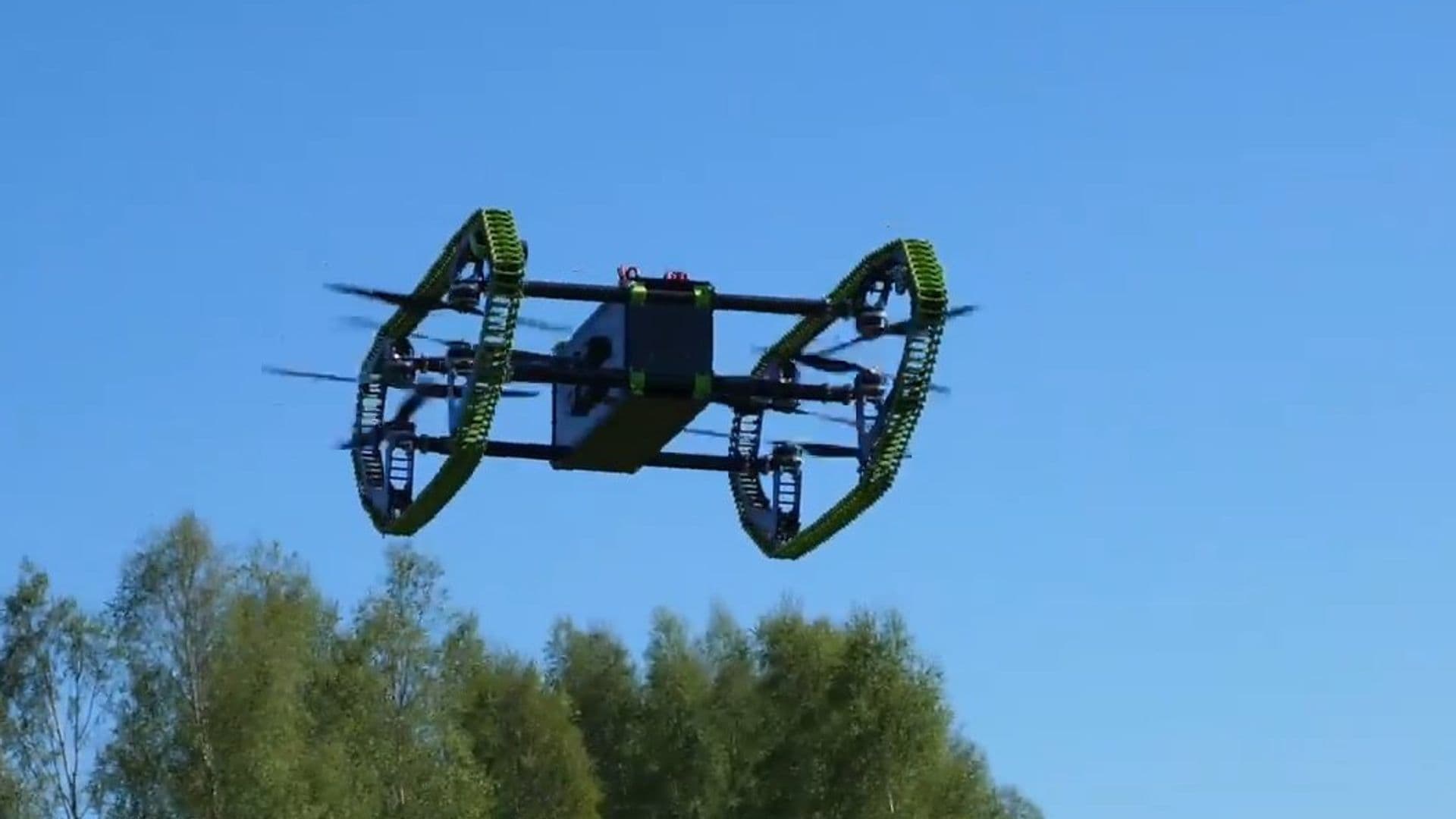
HUUVER is a hybrid UAV-UGV platform that delivers 20 minutes of multirotor flight endurance plus 10 hours of ground driving on the same airframe.
Source · HUUVER programme technical specifications
Dronehub led a seven-partner consortium across five EU countries on HUUVER: Poland (lead), Finland (LUT University), Spain (NTT Data Spain), Czech Republic (GINA Software), and Austria (BLADESCAPE, Brimatech Services), plus RECTANGLE in Poland.
Source · HUUVER consortium composition, EU Horizon 2020 records
2 more key facts
Total HUUVER programme budget was approximately $1.75M, with ~$1.30M EU contribution — the rest matched by consortium partners.
Source · EU Horizon 2020 funding agreement
Founder Vadym Melnyk was personally listed as the project coordinator on the EU programme record — an unusual position for an SME founder, normally held by large industrial primes or research institutes.
Source · EU Horizon 2020 official programme record, project #870236
In this piece
In 2011, Iranian forces captured a US RQ-170 reconnaissance drone by spoofing its GPS into landing in Iranian territory. Since 2022, GPS spoofing has been routinely documented over Eastern Europe and the Eastern Mediterranean — operational reality, not theoretical risk. HUUVER is the first UAV in the world that cannot be tricked about where it is.
HUUVER is a hybrid UAV-UGV — a drone that flies and drives — developed under EU Horizon 2020 grant agreement #870236, with Dronehub leading a seven-partner consortium across five EU countries. The world-first credential is that HUUVER integrated full Galileo Open Service Navigation Message Authentication (OS-NMA): cryptographically signed positioning that defeats GPS spoofing by design.
This post unpacks what Galileo authentication actually does, why the hybrid mobility envelope unlocks mission profiles that pure-flight or pure-ground platforms can't serve, and what the consortium-leadership credential means for the next generation of EU defense and federal-innovation programmes.
The two ceilings HUUVER was engineered to break
Most drone programmes break through one operational ceiling. HUUVER broke through two simultaneously.
The first ceiling is endurance. Multirotor UAVs flame out around twenty to thirty minutes. Fixed-wing platforms extend that to hours but pay the price in landing requirements, payload constraints, and operational complexity. Past kilometre fifteen of a real mission, the operator is either swapping batteries or pulling the drone back to base. The mission profiles that need continuous coverage past that horizon — long-line patrol, sustained inspection, denied-environment ISR — are exactly where pure-flight platforms fail.
The second ceiling is positioning integrity. Every consumer drone runs on unauthenticated GPS. Every adversary state with an electronic-warfare capability can spoof unauthenticated GPS. The threat has moved from research papers into operational reality — the 2011 Iranian capture of the US RQ-170 was the early warning shot, and 2022-onward Eastern European GPS-spoofing events have made it routine. A UAV that the operator cannot trust isn't a UAV the operator can deploy in any high-consequence mission.
HUUVER addresses both. The dual-mode mobility envelope (20 minutes flight + 10 hours ground) covers the endurance ceiling. Galileo OS-NMA integration covers the spoofing ceiling. The world had not had either on a single platform before.
Galileo authentication, in technical terms
Galileo is the European Union's sovereign global navigation satellite system — the EU equivalent of US GPS, Russian GLONASS, and Chinese BeiDou. Unlike GPS (whose civilian signals are unauthenticated), Galileo offers Open Service Navigation Message Authentication (OS-NMA) — a feature that cryptographically signs every navigation message broadcast from the satellites.
A receiver that supports OS-NMA can verify each navigation message against the agency's public key. If a signal didn't originate from a real Galileo satellite, the verification fails, and the receiver knows it's being lied to. This is fundamentally different from unauthenticated GNSS — an adversary spoofer cannot reproduce the cryptographic signature without the agency's private key, which means spoofing becomes a cryptographic attack rather than a radio-frequency one. Cryptographic attacks at operational scale require resources adversary electronic-warfare units don't have.
For a UAV that has to be trusted by an operator — defense, critical infrastructure, sovereign border patrol, any high-consequence mission — OS-NMA-authenticated positioning is non-negotiable. An unauthenticated drone can be redirected into hostile territory by a spoofer, captured intact by inducing a false landing position, or denied operation entirely by RF jamming combined with spoofing.
HUUVER was the first drone in the world to integrate full OS-NMA. The integration work, the regulatory coordination with the European Union Agency for the Space Programme (EUSPA — the EU agency that operates Galileo), and the flight validation were all completed as part of the consortium programme. The same integration pattern is now reusable across any future Dronehub UAV, or any licensee's platform, that needs sovereign positioning.
The hybrid mobility envelope
The classical drone choice is between aerial mobility (fast, expensive in endurance) and ground mobility (slow, but lasts hours). HUUVER eliminates the choice.
The flight mode is a VTOL multirotor — 20 minutes of endurance, fast relocation across terrain obstacles, aerial ISR over inaccessible zones. The ground mode is a driving / climbing chassis — 10 hours of endurance, dwell time on a target, low-signature operation in environments where airborne presence would be regulated or compromised.
The transition is the engineering hard part. Going from flight to ground mid-mission, without operator intervention, without losing the sensor payload, without breaking communications continuity — that is what the consortium spent the programme delivering. The output is a single platform that can park, observe, relocate by air, observe again, drive into a denied environment that wouldn't allow continued flight, dwell, and return. No fleet of two specialised platforms. One platform, one operator, one mission.
The sensor payload reflects the dual envelope: a Velodyne Puck LITE LiDAR for 3D scene reconstruction at both modes, an Nvidia Jetson AGX Xavier for on-board compute, FLIR thermal plus visible imaging, and a modular payload bay for mission-specific sensors (chem-bio detection, RF survey, hyperspectral imaging).
The consortium
HUUVER was Dronehub's first EU-consortium leadership role. Seven partners, five countries, coordinated from Poland by an SME. Vadym Melnyk is personally listed as project coordinator on the EU programme record — a position normally held by a large industrial prime or a research institute, rarely by an SME founder. That pattern has repeated across the Dronehub R&D portfolio since: when EU funders want a complex multi-country consortium led, they call us.
The consortium composition is itself a procurement signal. Five of the seven partners are based in NATO members (Poland, Finland, Czech Republic, Spain). The cross-border allied pattern is exactly what the European Defence Fund (EDF) and NATO DIANA programmes require for downstream proposals.
The named partners:
- Dronehub (Poland) — consortium lead, airframe, autonomy stack, mode-transition logic, integration
- RECTANGLE (Poland) — engineering partner
- LUT University (Lappeenranta, Finland) — academic research partner
- NTT Data Spain (Spain) — software and systems integration
- GINA Software (Czech Republic) — command and control integration
- BLADESCAPE (Austria) — composite engineering
- Brimatech Services (Austria) — dissemination and exploitation
What HUUVER unlocks for procurement
For a US programme office looking at GNSS-resilience or dual-mode mobility — HUUVER is the answer to "has anyone shipped a UAV with cryptographically authenticated positioning, in a NATO-allied consortium, with a real flight programme behind it?" Yes. NASA SBIR/STTR, AFWERX Open Topics on GNSS-resilient autonomy, and DIU dual-mode-mobility pilots are all direct fits.
For an EU prime assembling a Horizon Europe, EDF, or NATO DIANA consortium on UAV autonomy or counter-spoofing — HUUVER is the SME credential proving Dronehub has led a 7-partner, 5-country consortium to a successful public-programme outcome. Bring us in as work-package lead or technical SME and you import the consortium-leadership experience along with the technology.
For an operator with an active mission profile in search-and-rescue, hard-terrain patrol, vessel inspection, or denied-environment ISR — the HUUVER platform deploys today, under license or direct purchase, manufactured at the Dronehub Jasionka factory in Poland.
The full HUUVER case study with technical specifications, hardware loadout, and consortium detail is on the project page. For licensing or a co-development conversation, open the contact form.
FAQ
- What is Galileo authentication and why does it matter?
- Galileo Open Service Navigation Message Authentication (OS-NMA) cryptographically signs the navigation messages broadcast by the EU's Galileo satellites. A receiver that supports OS-NMA can verify the signature against the public key — if the signal didn't come from a real Galileo satellite, verification fails. For a UAV operating in environments where GPS spoofing is a real threat (adversary electronic warfare, denied-environment operations, contested airspace), authenticated positioning is the difference between a system that can be trusted and one that can be redirected by an attacker.
- Why hybrid UAV-UGV?
- Pure-flight drones top out at ~20-30 minutes of endurance. Pure-ground robots can't fly over obstacles. Many real missions need both — search-and-rescue in mixed terrain, hard-to-reach industrial inspection, subterranean ISR, denied-environment operations. HUUVER combines a VTOL multirotor envelope with a ground-driving mode that delivers 10+ hours of endurance, on a single platform with one operator.
- What use cases does HUUVER serve?
- Search and rescue in mixed terrain (forest, mountain, post-disaster urban), border and infrastructure patrol with Galileo-authenticated positioning, hard-to-reach industrial sites (vessels, refineries, dams, large plants), subterranean ISR (tunnels, urban canyons, parking structures), and sovereign defense operations where cryptographically authenticated positioning is a procurement requirement.
- Is HUUVER available outside the EU?
- Yes. The HUUVER platform and the Galileo-authentication IP are available for license through Dronehub. The dual-mode mobility stack, the terminal-approach guidance, and the integrated airframe are licensable as building blocks. For US programme offices, Dronehub Inc. is a Delaware C-Corp and SBIR/STTR-eligible — the NASA SBIR, AFWERX Open Topics on GNSS-resilient autonomy, and DIU dual-mode-mobility pilots are all direct fits.
- What sensors does HUUVER carry?
- HUUVER includes a Velodyne Puck LITE LiDAR for 3D scene reconstruction, an Nvidia Jetson AGX Xavier for on-board compute, and FLIR thermal plus visible-light imaging. The sensor bay is engineered to accept mission-specific payloads — chemical-biological detection, RF survey, hyperspectral imaging — depending on the deployment.