Key facts
HUUVER is a hybrid UAV-UGV platform — 20 minutes of multirotor flight endurance plus 10 hours of ground driving endurance on a single airframe and single operator.
Source · HUUVER programme technical specifications
HUUVER was the first UAV in the world to integrate full Galileo Open Service Navigation Message Authentication (OS-NMA) — cryptographically signed positioning that defeats GPS spoofing by design.
Source · HUUVER programme outcomes, EU Horizon 2020 grant agreement #870236
Pure-flight UAS fail in subterranean and overhead-obstructed environments because GPS is denied (no sky-view for satellite reception), ceilings limit flight envelope, RF mesh-network breaks down with overhead obstruction, and battery-limited flight time compounds when the mission requires waypoint dwell.
Source · Operational analysis of UAS limitations in confined and denied environments
3 more key facts
Pure-ground robots fail when missions require climbing over rubble, navigating vertical infrastructure, or traversing open spaces between buildings — the air mobility envelope is required for those segments. The hybrid envelope spans both.
Source · Comparative analysis of pure-UGV deployment limitations
HUUVER carries a Velodyne Puck LITE LiDAR for 3D scene reconstruction in low-light and GPS-denied environments, an Nvidia Jetson AGX Xavier for on-board compute (edge inference without uplink dependency), FLIR thermal plus visible-light imaging, and a modular payload bay for mission-specific sensors.
Source · HUUVER sensor and compute specifications
Operational profiles include subterranean ISR (tunnels, urban underground, parking structures), urban canyon ISR (between tall buildings with limited overhead access), search-and-rescue in mixed terrain (forest, mountain, post-disaster urban), denied-environment border and infrastructure patrol, post-disaster building assessment, and sovereign defense operations requiring cryptographically authenticated positioning.
Source · HUUVER deployment-pattern documentation
In this piece
Tunnels. Cellars. Parking structures. Urban canyons. Subterranean infrastructure. Post-disaster buildings with compromised structural integrity. These are the environments where pure-flight UAS just fail — and where pure-ground robots can't reach the segments that require air mobility either. HUUVER is the hybrid UAV-UGV platform that handles both envelopes on a single airframe with one operator. This is the operational case for the platform across the use cases where the conventional UAS catalog runs out.
This post walks through why the environments break pure-flight, why hybrid mobility is the correct architectural answer, why Galileo authentication compounds the advantage in those environments specifically, and where the platform deploys across defense, federal, and specialised civilian missions.
The environments where pure-flight UAS run out
A multirotor UAV is a good tool for most outdoor missions in unobstructed airspace. The cases where it isn't a good tool are specific and operationally consequential.
Subterranean environments. Tunnels, sewers, underground infrastructure, mining shafts, urban undergrounds. The defining property is that the operational space is enclosed overhead. The four failure modes compound: no sky-view for GNSS reception so navigation is denied, low ceilings limit the multirotor's flight envelope and complicate collision avoidance, RF mesh-network degrades with overhead concrete and earth attenuation, and the battery-limited endurance becomes binding when the mission requires waypoint dwell rather than transit.
Parking structures and urban interiors. Similar failure modes to subterranean. The ceilings are lower than typical operational altitude. The structural concrete attenuates RF. The lighting is often low and variable, making visible-light navigation unreliable. The GNSS reception is degraded but not always fully denied — which is in some ways worse, because the receiver gets enough signal to produce a position fix but the fix is unreliable.
Urban canyons. The narrow corridors between tall buildings. GNSS reception is degraded by multipath reflection rather than full denial — the receiver sees signal but the signal arrives via reflection paths, producing position errors. RF command-and-control links suffer from the same multipath effects. The corridor geometry limits operational manoeuvring and increases collision risk against buildings on both sides.
Post-disaster buildings. Compromised structural integrity, partial collapse, debris-strewn floor surfaces, no GNSS reception inside the structure. The mission profile typically requires locating people or critical assets inside, which is high-dwell, low-mobility, mixed-environment work that pure-flight UAS cannot sustain.
Denied-airspace environments. Adversary-controlled airspace, active electronic-warfare environments, GNSS-spoofed environments. The operational airspace itself becomes contested — and pure-flight systems running unauthenticated GNSS can be redirected, captured, or denied operation entirely.
In all five environments, the conventional UAS catalog fails. The platforms that work in open-airspace operations stop working when the operational envelope narrows or the spectrum gets contested.
Pure-ground robots have the inverse problem
The instinctive response to "flight doesn't work here" is "use a ground robot instead." Pure-UGV systems do solve some of the problems — GPS-denied navigation via SLAM is mature on ground platforms, the endurance ceiling shifts from 20-30 minutes to multiple hours, the ceiling-collision problem disappears.
But pure-ground robots have their own failure envelope.
They fail on vertical infrastructure — climbing rubble piles, accessing upper floors of damaged buildings, traversing stairs efficiently, getting onto rooftops for line-of-sight communication. They fail on open spaces between buildings — the segments of an urban-canyon mission that require crossing from one structure to another. They fail on obstacle traversal at scale — debris fields, broken terrain, water gaps, fences. They fail on observation altitude — when the mission requires looking down on something, a ground robot can't do that.
The combined operational envelope — subterranean transit plus vertical infrastructure plus open-space crossings plus observation altitude — exceeds what either pure-flight or pure-ground systems can deliver alone. The mission requires both envelopes.
Hybrid mobility on a single platform
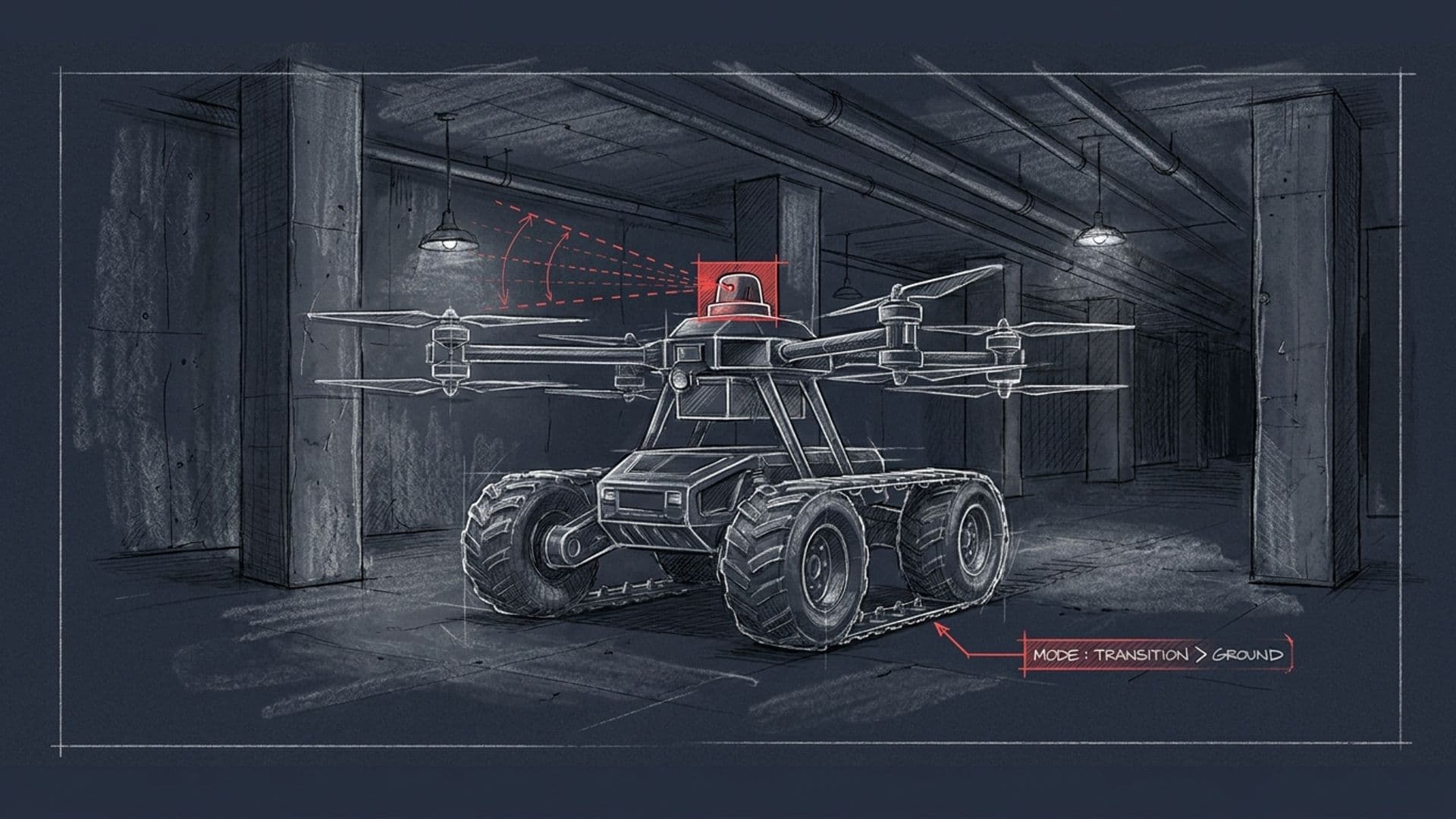
HUUVER's architectural answer is to put both envelopes on a single airframe with one operator. The flight mode is a VTOL multirotor with the operational characteristics of a small ISR drone — 20 minutes endurance, vertical lift, aerial observation, terrain traversal. The ground mode is a driving / climbing chassis with 10 hours endurance — dwell, low-signature operation in environments where airborne presence is regulated or compromised, persistent observation of a static target.
The mode-transition mechanism is the central engineering work. Going from flight to ground driving requires the platform to land controlled, stow the rotors, transition the weight to the wheel chassis, re-orient the sensor payload, and re-establish communications continuity under the new airframe geometry. The transition operates autonomously — without operator intervention during the cycle — and preserves the mission state of the sensor payload and the autonomy stack.
The output is a platform that can launch from a forward operating position, fly to the target area, observe from altitude, land on a roof or in an alley or in an open space, drive into a subterranean environment that wouldn't support continued flight, dwell at a target for hours, return to an extraction point, take off again, and fly back to the operator. No fleet coordination between two specialised platforms. One platform, one operator, one mission envelope.
Why Galileo authentication compounds the advantage
GNSS spoofing has matured from research demonstration to operational adversary capability across 2022 and the years following. The threat profile is bimodal — sophisticated state-level electronic-warfare units operate spoofing at theatre scale, while inexpensive consumer-grade spoofing equipment is widely available and operates at tactical scale. Both modes are documented across Eastern Europe and the Eastern Mediterranean.
The denied environments where HUUVER deploys are exactly the environments where spoofing is most effective. Subterranean environments have weak legitimate GNSS signal; a local spoofer needs less transmit power to dominate the receiver. Urban canyons have multipath-corrupted legitimate signal; spoofing imposes coherent fake signal that looks cleaner than the multipath corruption, so the receiver locks onto the spoof preferentially. Denied-airspace environments are contested by definition; spoofing is part of the active threat catalog.
HUUVER's Galileo OS-NMA receiver runs cryptographic verification on every navigation message. The Galileo signals carry signatures generated against the European Union Agency for the Space Programme's private key; the receiver verifies against the public key on every message. Spoofed signals cannot reproduce the signature without the agency's private key, which is held inside the EUSPA infrastructure. The receiver detects the spoof and rejects the navigation message.
The authenticated navigation layer doesn't make HUUVER immune to all electronic-warfare threats — it doesn't address active jamming, doesn't address kinetic threats, doesn't address adversary cyber on the command-and-control link. But it removes the largest single threat to operational navigation in denied environments, which is what unlocks reliable use of the platform in the missions it's designed for.
Operational profiles
The deployment-pattern catalog includes five primary categories, plus specialised civilian use cases.
Subterranean ISR. Tunnels, sewers, underground infrastructure, parking structures, mining environments. The combination of GNSS-denied SLAM navigation, mode-transition (fly to entrance, drive into the subterranean envelope), and on-board edge inference makes HUUVER one of the few platforms operationally suited for the mission profile. The use case includes border-tunnel detection (smuggling, irregular crossings), urban-underground threat assessment (criminal-organisation infrastructure, terrorist-cell facilities), and mining safety surveys.
Urban canyon and built-up area ISR. Narrow corridors between tall buildings, GNSS multipath environments, RF-attenuated operational space. The hybrid mobility envelope reduces the platform's exposure to building-to-building collision risk and allows transition to ground driving when overhead corridors are too narrow or obstructed for safe flight.
Search-and-rescue in mixed terrain. Forest, mountain, post-disaster urban environments. The mixed-mode envelope handles search patterns that pure-flight or pure-ground systems can't sustain — fly over obstacles, drive through rubble, dwell at survivor locations for stretcher-team coordination. The 10-hour ground endurance is the property that makes long-duration searches feasible.
Denied-environment border and infrastructure patrol. Sovereign border surveillance under electronic-warfare contest, critical-infrastructure perimeter patrol in spoofing-vulnerable environments, transit-corridor surveillance under adversary EW posture. The Galileo authentication is the load-bearing capability here.
Post-disaster building assessment. Earthquake, fire, explosion damage assessment. Structural integrity unknown, GNSS unavailable inside structures, mixed-mode mobility required. The HUUVER's 3D LiDAR scene reconstruction generates a structural model that informs emergency-response decisions on stretcher-route planning, structural stability assessment, and trapped-survivor location.
Procurement pathways
For US defense and federal innovation — direct contract through Dronehub Inc., with the platform mapping to NASA SBIR programmes on dual-mode autonomy and GNSS-resilient navigation, AFWERX Open Topics on tactical-edge operations and hybrid mobility, DIU CSO on dual-use autonomy and counter-spoofing capability, DHS S&T on subterranean and confined-space ISR. The Section 848-equivalent compliance and the sovereign supply chain documentation survive federal procurement review on first cycle.
For EU defense — Dronehub Sp. z o.o. and the EDF / NATO DIANA / Horizon Europe Cluster 4 pipelines. The HUUVER consortium-leadership credential (7 partners across 5 EU countries, Vadym Melnyk personally listed as project coordinator on the EU programme record) is the SME signal for prime-led consortia building UAS-autonomy proposals.
For Five Eyes and NATO non-EU allies — the dual-domicile structure handles direct procurement. UK MoD, Canadian DND, Australian DoD, Japanese ministry-of-defense procurement pathways.
For specialised civilian use cases — search-and-rescue agencies, disaster-response authorities, hazmat survey operators, mining safety operations — direct industrial licensing through the appropriate Dronehub entity.
The full HUUVER project case study lives at /projects/huuver. The Galileo-authentication deep-dive is at /blog/we-are-proud-to-present-the-huuver-our-new-hybrid-drone-that-flies-and-rides. The defense-industry context is at /industries/defense; public-safety at /industries/public-safety. For a procurement-readiness conversation, open the contact form.
FAQ
- Who offers hybrid UAV-UGV systems in Europe?
- Dronehub's HUUVER is a hybrid UAV-UGV system built in Europe: it drives on the ground and flies in the air, and it is the first UAV in the world with full Galileo OS-NMA authentication, developed under a Polish R&D Centre programme. For denied and subterranean environments where pure-flight UAS fail (GPS denial, low ceilings, RF attenuation), the ground-and-air hybrid is the structural answer.
- Why do pure-flight UAS fail in subterranean environments?
- Four overlapping reasons. First, GPS denial — subterranean environments don't have sky-view for satellite reception, so unauthenticated GPS-based navigation fails immediately. Second, ceiling constraint — tunnels, cellars, parking structures, and underground infrastructure have low ceilings that limit the multirotor's flight envelope and make collision avoidance much harder. Third, RF mesh-network degradation — overhead concrete and earth attenuate the command-and-control RF link, breaking the operator's positive control over the airborne system. Fourth, battery economics — when the mission requires waypoint dwell rather than transit, the multirotor's 20-30 minute endurance ceiling becomes the limiting constraint, and there's no resupply mechanism in a denied environment.
- Why does Galileo authentication matter for denied environments?
- Because adversaries operating in those environments increasingly deploy GPS spoofing as part of their electronic-warfare posture. Spoofing in a subterranean or urban-canyon environment is even easier than in open airspace — the legitimate GNSS signal is already weakened by structural attenuation, so a local spoof signal needs less power to dominate the receiver. An unauthenticated UAS in a spoofed environment can be redirected, denied operation, or captured. HUUVER's Galileo OS-NMA receiver verifies the cryptographic signature on every navigation message and rejects spoofed signals — the navigation integrity is preserved in environments where unauthenticated systems can be defeated by inexpensive adversary tooling.
- What's the mode-transition mechanism?
- HUUVER transitions between flight and ground driving autonomously, without operator intervention, without losing communications continuity, and without losing the sensor payload's mission state. The engineering of the transition is the harder half of the platform — going from VTOL flight to ground driving requires rotor stowage, transition of weight to the wheel chassis, sensor-payload orientation switch, and re-establishment of communications under the new airframe geometry. The transition was the central R&D risk of the EU Horizon 2020 programme that funded HUUVER, and the deliverable artefact is a single platform that handles both envelopes operationally rather than as a stunt-demo.
- Where has HUUVER been tested?
- Under EU Horizon 2020 grant agreement #870236, with seven consortium partners across five EU countries. The consortium included Dronehub as lead (Poland), Fly4Future and GINA Software (Czech Republic), NTT Data Spain (Spain), LUT University (Finland), and BLADESCAPE and Brimatech Services (Austria). Testing was conducted across the consortium's facilities under the programme's technical-validation framework, with EU programme-record sign-off on the platform's mode-transition, sensor-integration, and Galileo-authentication capabilities. The platform is available for further deployment-specific validation under licence.
- What sensors does HUUVER carry, and why?
- Velodyne Puck LITE LiDAR for 3D scene reconstruction — operates in low-light and GPS-denied environments, builds a continuously updating model of the surrounding environment that supports both navigation and ISR. Nvidia Jetson AGX Xavier for on-board compute — runs the autonomy stack, the SLAM pipeline, and any mission-specific AI inference locally without uplink dependency (critical for denied-environment operations where uplink is unavailable). FLIR thermal plus visible-light imaging — covers the day, low-light, and through-obscurant detection ranges. The modular payload bay accepts mission-specific sensors: chemical / biological detection, RF survey, signals intelligence, hyperspectral imaging, or specialised optical payloads for specific operator needs.
- What's the procurement pathway for HUUVER?
- For US defense and federal innovation — direct contract through Dronehub Inc., with the platform mapping to active topic areas. NASA SBIR / STTR programmes on dual-mode autonomy and GNSS-resilient navigation; AFWERX Open Topics on hybrid mobility and tactical-edge operations; DIU CSO on dual-use autonomy and counter-spoofing capability; DHS S&T on subterranean and confined-space ISR. For EU defense — Dronehub Sp. z o.o. and the EDF / NATO DIANA / Horizon Europe Cluster 4 pipelines, with the HUUVER consortium-leadership credential as the SME signal. For Five Eyes and NATO non-EU — the dual-domicile structure handles direct procurement. For specialised civilian use cases (search-and-rescue, disaster response, hazmat survey) — direct industrial licensing.